
ECDIS
The Electronic Chart Display and Information System (ECDIS) is part of the navigational chart system used by naval vessels. It is a navigation information system that connects with other navigation equipment such as GPS, gyro compass, radar, ARPA, and echo sounder. ECDIS features automatic functions like route planning, route monitoring, automatic ETA calculation, and ENC updates, helping the ship's crew determine positions and directions more easily. ECDIS also provides many other advanced navigation and safety functions, including continuous data recording for future analysis. ECDIS can integrate and display information from other nautical publications, such as tide tables and sailing directions, and incorporate additional maritime information like radar data, weather, ice conditions, and automatic ship identification. We offer IECS series and ESC 9000 series ECDIS products, these products have advantages such as easy operation and multi functions.
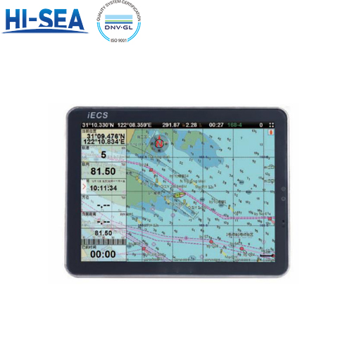
Overview
IECS series
Characteristic
Touch screen operation, remote control plus mouse and key board optional;
Global chart, international standard S57/63, support satellite image chart;
Support VGA or HDMI display;
Built-in AIS optional.
Photos of details

Parameter table
Model | IECS-12 | IECS-15 | IECS-17 | IECS-19 |
Display | 12’’ | 15’’ | 17’’ | 19’’ |
Resolution | 800*600px | 1024*768px | 1280*1024px | 1280*1024px |
Power | DC 24V(11-35V) | |||
Power supply | High-performance, full isolated, PWM control of power supply | |||
Mount | Bracket mount or flush mount | |||
Power consumption | ≤20w | |||
Language | Simple Chinese, traditional Chinese, English (can be customized) | |||
Map format | S57, S63(ENC), CJ57,CJ63 | |||
ESC 9000 series
Features
The electronic chart is including global chart, supporting vector chart IHO, S57, S63 and RNC raster chart;
Flexible expand ability and many navigation sensor interface sallow the ECS to be networked with AIS, GPS, Echo Sounder, Compass, Log, ARPA and others to consolidate the navigation system;
The electronic chart can be overlaid with a variety of navigation data such as ship's position, heading, speed and others to facilitate safe and efficient navigation;
Navigation data for the past 12 hours can be recorded and play back;
Detail pictures

General parameter
Model | ESC9000-17 | ESC9000-19 | ESC9000-22 |
Display unit | 17’’ | 19’’ | 22’’ |
Resolution | 1280*1024px | 1280*1024px | 1680*1050px |
Power supply | DC 24V(11-35V) | ||
Power | High-performance, full isolated, PWM control of power supply | ||
Installation | Bracket or flush mount | ||
Language | Simplified Chinese, English | ||