
Multifunctional Electronics Chart System
The Multifunctional Electronics Chart System is a comprehensive navigation solution that integrates various marine navigational tools into one system. It features detailed electronic charts, real-time GPS positioning, and route planning capabilities. Additionally, it supports weather overlay, AIS target tracking, and radar integration. Designed for ease of use, it offers a user-friendly interface with customizable display options. This system enhances situational awareness and decision-making for safe and efficient maritime navigation.
Overview
Features of product
The electronic chart is including global chart, supporting vector chart IHO, S57, S63 and RNC raster chart.
Flexible expand-ability and many navigation sensor interfaces allow the ECS to be networked with AIS, GPS, echo sounder, compass, log, ARPA and others to consolidate the navigation system.
The electronic chart can be overlaid with a variety of navigation data such as ship’s position, heading, speed and others to facilitate safe and efficient navigation.
Navigation data for the past 12h can be recorded and playback.
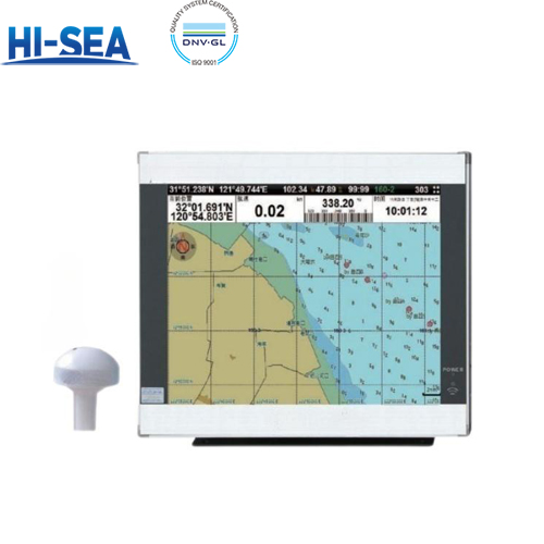
Product show

Specification
General parameter | |||
Display Unit | 17” | 19” | 22” |
Resolution | 1280*1024px | 1280*1024px | 1680*1050px |
Power Supply | DC24V(11~35V) | ||
Power | High-performance,full isolated,PWM control of power supply | ||
Installation | Bracket or Flush Mount | ||
Language | Simplified Chinese,English | ||
Technical data | |||
Chart Format | IHO S57,S63(ENC),RNC | ||
Display Modes | North Up,South Up,Course Up,Heading Up | ||
Display of Data | Own ship:Position,COG,SOG,Heading;Route:Planned route,Monitoring route; | ||
Route/Waypoint | Routes≥100;Waypoints≥5000 | ||
Alarm | Off track,Communication,Positioning,Collision,Alert area,danger | ||
Voyage Calculation | Range/Bearing to destination,Offtrack,TTG,ETA | ||
Navigation Log | ≥12h | ||
Track Display | ≥240min | ||
Other Functions | Measurement(Distance, Bearing, CPA/TCPA), User chart function, Log book, Night/day display modes, ARPA target display,etc | ||
Interface | |||
Input/Output | GPS(GGA,GLL,GSA,GSV,RMC,VTG) | ||
Input | AIS(VDM,ABM,BBM), Gyrocompass(HDT), Speed(VBM), Echo sounder(DBT,DPT), | ||